
the Chesapeake Western serviced poultry plants, dairies, food processors, and local industries around Harrisonburg and Elkton
Source: Virginia Department of Rail and Public Transportation (DRPT), Virginia Railroad Map (2018)
the Chesapeake Western serviced poultry plants, dairies, food processors, and local industries around Harrisonburg and Elkton
Source: Virginia Department of Rail and Public Transportation (DRPT), Virginia
Railroad Map (2018)
The Chesapeake, Shenden, and Western Railway was chartered on January 22, 1892. The company changed its name to Chesapeake and Western Railroad in 1895.1
The railroad ended up carrying primarily agricultural products within the Shenandoah Valley around Harrisonburg, and became known colloquially as the "Crooked and Weedy."
The original plans for the railroad were much grander.
The first concept was chartered in 1871 as the Washington, Cincinnati & St. Louis Railroad. It proposed to build a narrow gauge railroad stretching from Washington, DC to Cincinnati, Ohio. Like many other proposals during Reconstruction and subsequent financial recessions (such as the Panic of 1873), this grand vision for an ambitious southern railroad failed to attract enough capital from northern states or England. Only a little amount of roadbed grading was completed south of Massanutten Mountain.

in 1891, there was no railroad connection between Elkton-Harrisonburg
Source: New York Public Library, Map showing the location of battle fields of Virginia (1891)
The next vision was to link the Shenandoah Valley with the railroad junction at Gordonsville. The Chesapeake, Shendun, & Western Railroad planned in 1892 to transport coal from West Virginia to the east side of the Blue Ridge. The railroad's promoters also proposed to go west from Harrisonburg, across the Allegheny Front into the West Virginia coal fields at North River Gap.

the Chesapeake Western Railway was constructed to North River Gap at the base of Narrow Back Mountain in western Augusta County
Source: ESRI, ArcGIS Online
The Chesapeake, Shendun, & Western Railroad route to Gordonsville was planned to cross the Blue Ridge at Brown Gap. The "Shendun" in the name refers to the modern community of Grottoes.2

the Chesapeake, Shendun, & Western Railroad planned to cross the Blue Ridge at Brown Gap and connect to Shendun (Grottoes) - not to Elkton
Source: US Geological Survey (USGS), Harrisonburg, VA 1:125,000 topographic quadrangle (1892)
When the east-west Chesapeake, Shendun, & Western Railroad was proposed in 1892, there were already two north-south railroads in the Shenandoah Valley. The Baltimore and Ohio (B&O) Railroad had built the Valley Railroad west of Massanutten Mountain, with tracks running south from Winchester to Lexington by 1883. Its north-south line ran through the valley west of Massanutten Mountain.
The Norfolk and Western (N&W) Railroad had constructed a separate line, east of Massanutten Mountain. The Norfolk and Western acquired the Shenandoah Valley Railroad, initially financed by the Pennsylvania Railroad as a competitor to the Baltimore and Ohio. The Shenandoah Valley Railroad built track all the way south to a connection with the former Virginia and Tennessee Railroad at Big Lick. The junction was renamed Roanoke, and the Virginia and Tennessee Railroad was combined with the Shenandoah Valley Railroad to form the Norfolk and Western Railroad.3
The only east-west railroad crossing the entire Shenandoah Valley in 1892 was the Chesapeake and Ohio (C&O) Railroad. It went through the Blue Ridge Tunnel, through Staunton, to Covington. North of Staunton, "down" the Shenandoah Valley, the Virginia Midland Railway connected Front Royal to Strasburg before turning south to Harrisonburg. In 1892, the Richmond and Danville Railroad had leased the Virginia Midland Railway. The Southern Railway assumed control of it in 1894.

before 1896, there was no direct railroad connection between Harrisonburg and Elkton
Source: Library of Congress, Map showing the West Virginia Midland Railway and its connections (G.W. & C.B. Colton & Co., 1883)
The Chesapeake, Shendun, & Western Railroad was renamed the Chesapeake and Western Rail Road in 1895. The "Western" in the name reflected plans to reach the West Virginia coal fields. The "Chesapeake" in the name reflected plans to connect with the Chesapeake and Ohio at Gordonsville, which would carry the coal to Newport News.4
Another change, in addition to the railroad's name, was the location of the crossing of the Blue Ridge. The new plan was to cross at Powell Gap and connect to Elkton on the west side of the Blue Ridge, rather than to Shendun (now called Grottoes).5
The elevation of Powell Gap is 2,306 feet, a significant increase from Elkton's 971 feet. A railroad up Hawksbill Creek could also cut through the Blue Ridge at Simmon's Gap, which is only 2,244 feet high. The potential of hauling copper ore from the Hightop Copper Company, with its operations at 3,000 feet on Hightop Mountain, may have made the Powell Gap route more attractive despite the extra 62 feet in elevation compared to Simmon's Gap.
The Mountain Road from Richmond, later US Route 33, crossed the Blue Ridge via Swift Run Gap. The Chesapeake, Shendun, & Western Railroad sought a different route because the elevation of Swift Run Gap is 2,365 feet, slightly higher than Powell Gap's 2,306 feet.6

the Chesapeake Western Railway planned to cross the Blue Ridge at Powell Gap, rather than Simmon's Gap or Swift Run Gap
Source: ESRI, ArcGIS Online

a business decision determined that the Chesapeake, & Western Railroad would connect to Elkton, and topography determined how it might cross the Blue Ridge
Source: US Geological Survey (USGS), Harrisonburg, VA 1:125,000 topographic quadrangle (1892)
By 1896, track had been laid so trains could run between Bridgewater through Harrisonburg to Elkton. The Chesapeake and Western Railroad connected with the Southern Railway at Harrisonburg, and with the Norfolk and Western Railroad at Elkton. Operating costs were high; trains crossing the foothills of Massanutten Mountain had to climb a 2% grade.

the Chesapeake and Western Rail Road in 1896 (with seam of paper map in the middle)
Source: Library of Congress, Post route map of the state of Virginia and West Virginia (1896)
The Chesapeake and Western Railroad was renamed in 1900 to the Tidewater & West Virginia Railroad. That name lasted just a year. In 1901, W.E.D. Stokes bought it along with 50,000 acres of land in western Augusta County, and chose to call it the Chesapeake Western Railway.
Stokes extended the line 13 miles west past Bridgewater to North River Gap between Lookout and Narrow Back mountains. Narrow gauge railroads brought timber from the west to a site named Stokesville at the base of Narrow Back Mountain. The Imperial Extract Works at Stokesville produced the tanning fluids used to convert cowhides into leather from the bark. The Chesapeake & Western Railroad built shops and a turntable at Stokesville to keep the steam engines in a state of good repair.

in 1905, the Chesapeake Western Railway transported coal and other items, but most freight was related to forest products
Source: Annual Report of the State Corporation Commission of Virginia - Volume 2 (1905), Chesapeake Western Railway (p.148)
The sawmill at Stokesville closed in 1909. The few commercial quantities of coal available for shipment from there were mined out only a few years later.7
The Chesapeake Western might have lived up to its name and been extended east to the Chesapeake Bay, if W.E.D. Stokes had accepted a purchase offer from Henry H. Rogers. However, Stokes insisted upon a price that was too high for Rogers. After failing to acquire the Chesapeake Western, Rogers proceeded to build the Virginian Railway. He connected West Virginia coal fields with Sewalls Point at Norfolk.8
The Baltimore and Ohio Railroad and the Southern Railway built a Union Station at Harrisonburg in 1911. The Baltimore and Ohio Railroad still controlled the track running south from Harrisonburg to Lexington, while the Southern Railway controlled the track running north to Strasburg and on to Alexandria.
Those two railroads refused W.E.D. Stokes's request for the Chesapeake & Western Railway to use the Union Station. Stokes then proceeded to construct an overly-elaborate station in 1913 using white brick.
The white brick station was designed to show that the Chesapeake & Western Railway was a high-quality railroad, even though passenger traffic was low. The station was repaired and restored after fires in 1949 and 1980. A fire in 1982 resulted in closure of the building. The railroad sold the building in 2005, and the new owners restored the old depot for residential and commercial use in 2016.
The Union Station built by the Baltimore and Ohio Railroad and the Southern Railway closed in 1941. The Wetsel Seed Company bought that building in 1944, and in the 1950's demolished the structure to create a parking lot. Today the parking lot has been incorporated into the Harrisonburg Judicial Complex, so the Chesapeake & Western Railway building is the only remaining railroad station in Harrisonburg.9
The western end of the Chesapeake & Western Railway from Mt. Solon to Stokesville was shut down in 1930, after most of the standing timber had been harvested. Trains could reach Mt. Solon until 1933, but then the end of the line was moved further east to Bridgewater.
The railroad considered a proposal in 1938 to scrap the line and ship the rails to Japan. Instead, the Norfolk and Western Railway financed a sale to Don Thomas, who was the General Manager of the Chesapeake Western. That kept the Chesapeake Western Railway as an independent business, feeding agriculture-based traffic into the Norfolk and Western system at Elkton.
The Chesapeake Western Railway expanded south in 1943 by purchasing the old Valley Railroad track from Harrisonburg to Lexington. That track was owned by the Baltimore and Ohio Railroad, but had been an "island" separated from the rest of that railroad's network since the lease for the Strasburg-Harrisonburg track was transferred to the Richmond and Danville Railroad in 1886.10
The Staunton-Lexington section was abandoned, but the Chesapeake Western Railroad ran trains from Elkton/Harrisonburg to Staunton. At Staunton, cars could be interchanged with the Chesapeake and Ohio (C&O) railroad, providing an alternative to interchanging with the Norfolk & Western Railway at Elkton or the Southern Railway at Harrisonburg.
The Norfolk and Western Railway purchased the Chesapeake Western Railway in 1954. That ended its status as an independent railroad.
Norfolk and Western Railway stopped operating south of Pleasant Hill (Harrisonburg) in 1985. It abandoned the rest of the western extension from Pleasant Hill to Bridgewater in 1987 and razed the shops at Elkton in 1989. The former Valley Railroad track going south of Pleasant Hill towards Staunton was sold to the Buckingham Branch Railroad, an independent shortline, in 1993. which now interchanges most cars with the CSX in Staunton.

the Norfolk and Western Railway stopped operations south of Pleasant Hill (red circle) in 1985, and abandoned the track west of Pleasant Hill in 1987
Source: ESRI, ArcGIS Online
Most freight brought over the former Chesapeake Western line from Elkton today is feed imported to Harrisonburg from the Midwest. The railroad brings poultry food to supply the farmers raising chickens and turkeys, and poultry processors around Harrisonburg/Dayton export some of their products by rail. The old "Crooked and Weedy" is a "chicken feed" line today.
In 2026, the Commonwealth Transportation Board approved a $750,000 Rail Industrial Access grant to the Virginia Poultry Growers Cooperative to double the capacity of the rail connection to the grain unloading station just north of Harrisonburg. The expansion to 1,000 cars per year was expected to eliminate up to 1,700 truck trips annually on I-81, delivering soymeal from the Midwest and propane to the cooperative's feed mill site.11
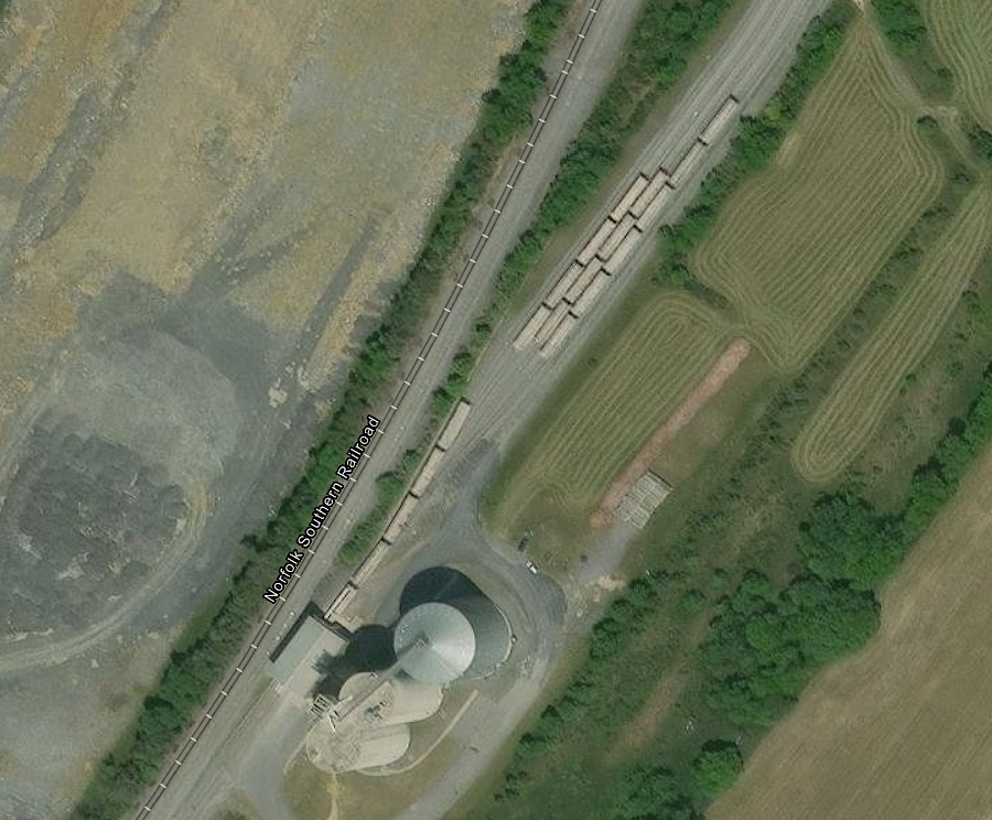
a 2026 Rail Industrial Access grant expanded the Chesapeake Western Railway connection to the Virginia Poultry Growers Cooperative grain mill north of Harrisonburg
Source: ESRI, ArcGIS Online
The Norfolk & Western Railway no longer runs north of Mount Jackson on the old Valley Railroad track towards Front Royal. The 2021 General Assembly funded a study to create a 48.5-mile Shenandoah Valley Rail Trail through Rockingham, Shenandoah and Warren counties, from Front Royal to Broadway.
That segment of the Valley Railroad, and later the Chesapeake Western Railway and the Norfolk and Western Railway, could become a transportation corridor for people enjoying outdoor recreation rather than shipment of freight. There were 23 bridges on the stretch of former railroad, so creation and management of the trail would require a substantial investment.12

nearly 50 miles of the old Valley Railroad could become the Shenandoah Valley Rail Trail
Source: Virginia Department of Transportation (VDOT), Rockingham, Shenandoah and Warren Counties - Shenandoah Valley Rail Trail Study

potential segments of the Shenandoah Valley Rail Trail between Broadway and Front Royal
Source: Virginia Department of Conservation and Recreation (DCR), Shenandoah Valley Rail Trail Feasibility Study (July 21, 2021)

the Shenandoah Valley in 1894, two years before the Chesapeake and Western Rail Road built track from Harrisonburg to Elkton
Source: Library of Congress, Map of northern Virginia (1894)

there are 23 bridges on the potential Shenandoah Valley Rail Trail
Source: Virginia Department of Conservation and Recreation (DCR), Shenandoah Valley Rail Trail Feasibility Study (July 21, 2021)