the Clinch River (red) is one of the upper tributaries of the Tennessee River, as is the Powell River to the west and the Holston River to the east
Source: US Geological Survey (USGS), Streamer
the Clinch River (red) is one of the upper tributaries of the Tennessee River, as is the Powell River to the west and the Holston River to the east
Source: US Geological Survey (USGS), Streamer
The Clinch River stretches nearly 300 miles from its headwaters on the Virginia-West Virginia border near Tazewell to its confluence with the Tennessee River at Kingston, Tennessee. Within Virginia, the Clinch River runs for 135 miles.1
It apparently was known as the Pelisipi by the Cherokee, but the colonists chose to name it after an early explorer. Supposedly a man named Clinch nearly died in a conflict with Native Americans on the river.
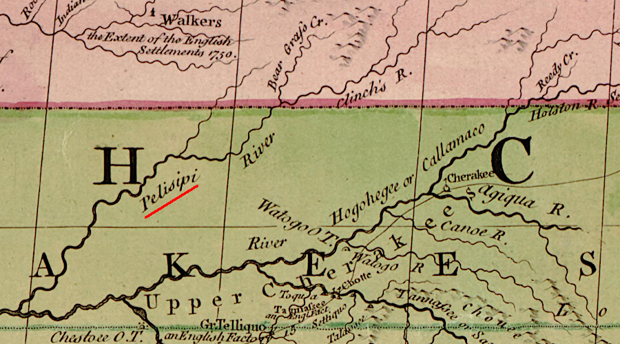
Pelisipi was the Cherokee name for the Clinch River
Source: Library of Congress, An accurate map of North America... (John Mitchell, 1775?)
In 1749 Clinch was part of a group organized by Adam Harman, an early German settler on the New River, to seized Jacob Castle from Castle's Woods on the "Pelisipi" River. Harman had accused Castle of conspiring with Native Americans to raid settlements on the New River, including Harman.
Harman's farm was on the north side of the New River at the ford used by immigrants migrating to the watersheds of the Tennessee and Kentucky rivers via the Wilderness Road. He was the first person seen by Mary Draper Ingles as she "followed the river" and returned back from Shawnee captivity in 1755.
The attempt to capture Jacob Castle in 1749 was unsuccessful. Shawnee assisted Castle in repelling Harman's posse. As they retreated, Clinch was shot crossing the river.
A year later on April 9, 1750, Dr. Thomas Walker crossed the river, probably at Looney's Gap near modern Sneedville. On his trip towards Cumberland Gap, Walker recorded in his journal:2
An alternative etymology is that in the early days of European settlement, someone crossing the river started to drown. Supposedly he yelled at others to grab and rescue him, calling out "Clinch Me."3
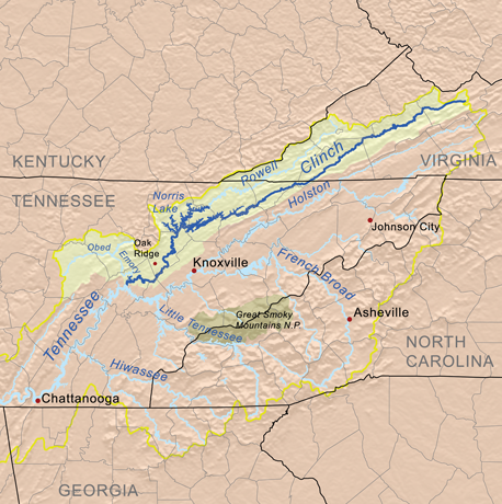 the Clinch River flows into the Tennessee River downstream of Knoxville
Source: Wikipedia, List of rivers of Virginia
Settlement along the Clinch River was slow. The river valley was narrow and offered limited acreage with good soil for farming. Transportation to the Atlantic Ocean ports was constrained by the steep mountains. Floating down the river to the port at New Orleans was an excessively long journey.
A French aristocrat, Pierre Francois du Tubeuf, sought to establish a settlement on the Clinch River in 1791. He was fleeing the French Revolution, and soon after arriving in Russell County he had exhausted the money he brought across the Atlantic Ocean. In a plea for financial support from the state government in Richmond, he claimed 20,000 Frenchmen were ready to settle in the Clinch River valley.
The General Assembly funded construction of a road from the county courthouse to the site of the proposed settlement on the river, called Sainte Marie on the Clinch. However, du Tubeuf was murdered by robbers in 1795. The proposed recruitment of French settlers died with him. The planned site of St. Marie on the Clinch is now the Sugar Hill unit of Clinch River State Park; just a chimney remains from the old settlement.4
Today the Clinch River is a biological hotspot at the headwaters of the Tennessee River. At the peak of the Ice Age about 18,000 years ago, the ice sheet isolated the Tennessee River from its earlier connection with drainages in the Mississippi River Valley. That isolation led to evolutionary changes in the fish and mussel species in the upper Tennessee River tributaries; new species developed.
According to the Nature Conservancy:5
a 1778 map omitted the Clinch and Powell rivers, west of the North Fork of the Holston River
Source: Library of Congress, A new map of the western parts of Virginia, Pennsylvania, Maryland, and North Carolina (by Thomas Hutchins, 1778)
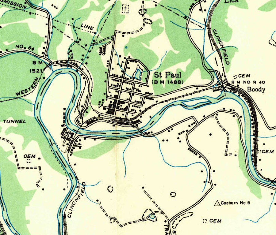 the Clinch River flowed in a meander west of St. Paul in 1935
Source: US Geological Survey (USGS), St. Paul VA 1:24,000 scale topographic map (1935)
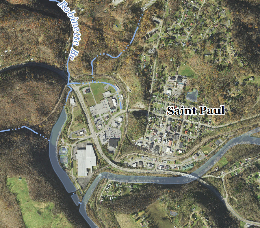 the former meander of the Clinch River, after a rechanneling project, is now Oxbow Lake Park
Source: US Geological Survey (USGS), St. Paul VA 1:24,000 scale topographic map (2022)
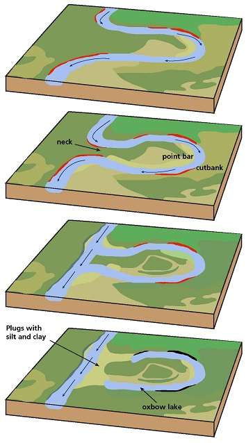 oxbows form naturally when a river erodes a new channel that isolates an earlier meander
Source: National Park Service, Fluvial Features - Meandering Stream