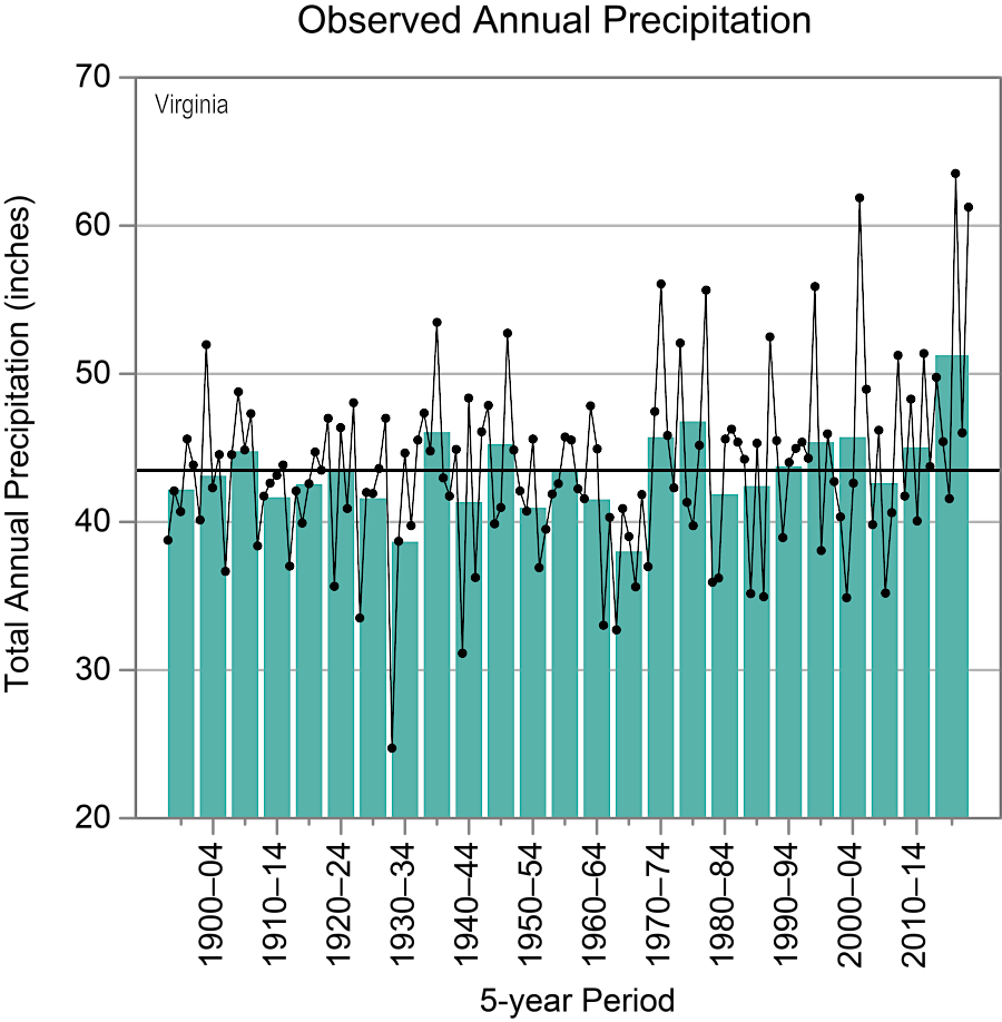
Virginia's most severe drought in modern times was during the Great Depression in 1930
Source: National Oceanic and Atmospheric Administration (NOAA), State Climate Summaries 2022 - Virginia
Virginia's most severe drought in modern times was during the Great Depression in 1930
Source: National Oceanic and Atmospheric Administration (NOAA), State Climate Summaries 2022 - Virginia
Rainfall in Virginia averages 43.5 inches annually. Each year the actual rainfall is above or below the median, sometimes significantly.1
Planning for interruptions in water supply is not a modern concept. Since Native Americans adopted agriculture 3,000 years ago, farmers have recognized the risk of dry periods when corn and other crops might not produce the expected supply of food. When English colonists arrived in 1607, they discovered Chief Powhatan kept stockpiles of dried corn in his warehouses in case of crop failure.
In Virginia, Native American farmers relied upon natural rainfall and did not develop irrigation systems. Towns were located near rivers and other water sources; wells were not dug to provide a reliable water supply for concentrations of people. Droughts lasting multiple years disrupted Native American populations, triggering migration and conflict. By chance, English colonists reached the New World at a time of unusually severe drought:2
Virginia's lowest annual rainfall in modern times was during the Great Depression in the 1930's. A 1990-2002 drought triggered modern water supply planning requirements.
At the peak of the 2002 drought, before rainfall began to recover after August:3
The General Assembly passed legislation in 2002 requiring localities to develop long-range water supply plans and to update them every 10 years. Water supply plans are based on the reduction of surface water flows during droughts, with reservoirs sized to stockpile adequate water until normal rainfall returns again.
Between 2008 and 2011, ten jurisdictions produced "local" plans to meet their individual needs. Other localities partnered together and published an additional 38 "regional" plans. Virginia's first statewide water supply plan was published in 2015:4
The 2015 plan predicted that the demand for water would increase 32% between 2010-2040. To meet the increased need, 77% of the additional water would come from surface water resources and 23$ from groundwater. To meet the need, new withdrawal locations would have to be established in addition to the existing 800 surface water withdrawals sites (reservoirs, plus stream and spring sources) and the existing 2,900 groundwater wells for public use.
Less than 20% of the surface withdrawals had a state-issued permit which would be reviewed/revised every 15 years. The unpermitted withdrawals were legal, "grandfathered" because they were in use before permitting requirements were established after passage of the Surface Water Management Area law in 1989. Users withdrawing surface water without a permit were not obligated to implement conservation procedures during a drought.
In addition, 1.6 million state residents relied upon individual private wells to tap groundwater aquifers. There were no conservation requirements for those private wells, though many users were already familiar with the need to reduce use during dry periods. A common phrase in rural areas for reducing the number of times a toilet was flushed was "if it's yellow, let it mellow; if it's brown, flush it down."
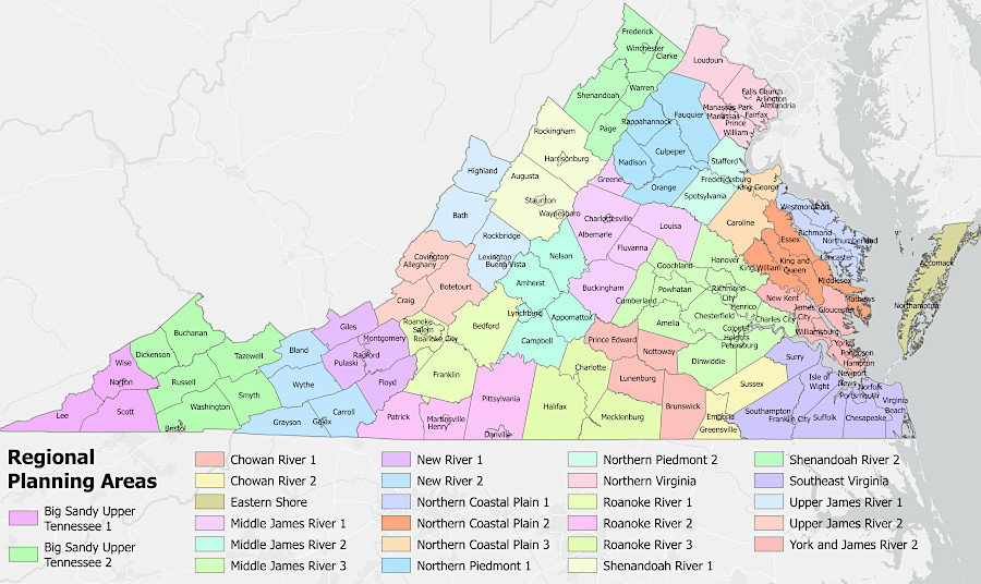
25 regional water supply plans are developed and updated in Virginia
Source: Virginia Department of Environmental Quality (DEQ), Regional Planning Areas Map
The Ground Water Management Act of 1992 defined two Groundwater Management Areas and permitting requirements for large withdrawals of 300,000 gallons or more in any one month. Accomack and Northampton counties are included within the Eastern Shore Groundwater Management Area. The Eastern Virginia Groundwater Management Area was expanded on January 1, 2014 to include all the land between Interstate 95 and the Chesapeake Bay.
The volume of groundwater pumped to the surface for beneficial use is not limited outside of the two designated Groundwater Management Areas. Local governments may require a construction permit before a well is drilled for a household to obtain drinking water or for a business to obtain water for commercial or industrial use. The Virginia Department of Health (VDH) issues permits for drinking water wells. For rural areas, the review ensures that the well will be located far enough away from any septic system to minimize the risk of contamination.
The amount of groundwater withdrawn for homeowner use is not regulated by state or local agencies. Large withdrawals by water utilities and industrial users do have the potential to lower the water table, as demonstrated most clearly by the creation of "cones of depression" by paper mills at West Point and Franklin.
Across Virginia, a lower water table can cause wells of other users to go dry. In eastern Virginia, a lower water table can result in land subsidence and saltwater intrusion.5
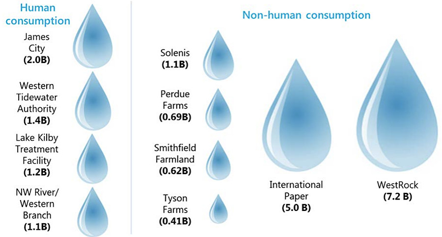
in 2016, two paper mills were the primary groundwater users in eastern Virginia
Source: Joint Legislative Audit and Review Commission (JLARC), Effectiveness of Virginia's Water Resource Planning and Management (p.ii)
The Virginia Department of Environmental Quality requires major users to report surface water withdrawals which began on or after July 1, 1989. Thresholds are:6
For surface water, Virginia water law is based on the Riparian Doctrine. Owners of waterfront property are entitled to withdraw surface water from rivers and impoundments, so long as their withdrawal does not unreasonably interfere with users upstream or downstream. Totally draining a stream and leaving it non-navigable, or killing all the fish, would be an unreasonable use.
In western states, where rainfall is less and water shortages are more common, water rights are allocated by state agencies using the Prior Appropriation Doctrine. "Water rights" are based on when a withdrawal for beneficial use first started (and has never stopped). In states where the Prior Appropriation Doctrine is applied, property owners adjacent to a stream do not have automatic authorization to withdraw a single drop of water.7
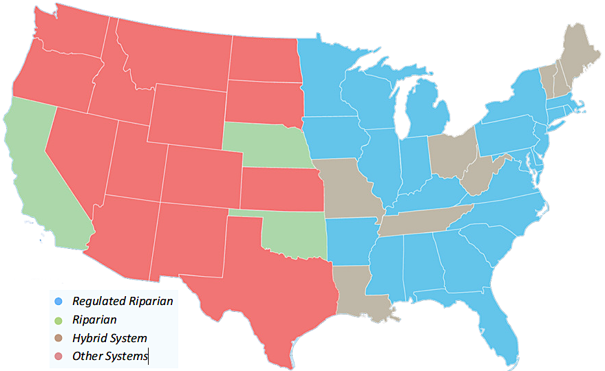
most eastern states have sufficient rainfall and water law is based on riparian rights
Source: Sea Grant Law Center, Overview of Riparian Water Rights
Water supply planning requires predicting changes in both demography and patterns of use. When Virginia's population increases, there will be more demand for water. That increasing demand may be offset by water conservation efforts by homeowners, reducing per capita requirements. Commercial and industrial users can reduce their demand for water, as can agricultural operations. Jurisdictions planning for construction of expensive new reservoirs have to estimate if future demand will justify the investment.
Demand for water to cool data centers is a potential water supply challenge in Virginia. The Interstate Commission on the Potomac River Basin (ICPRB) published the "2025 Washington Metropolitan Area (WMA) Water Supply and Demand Study" in 2025. Evaporation of cooling water was a consumptive use and Dominion Energy estimated a 135% increase in electricity need within its Virginia service area by 2050 as data centers were completed.
The expansion within the Potomac River basin could cause a water shortage by 2050. Impact would be most obvious during peak demand in the summer during a drought.
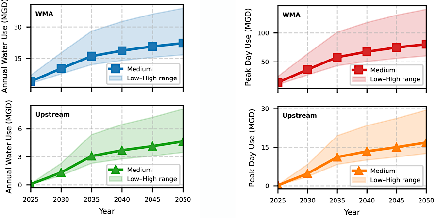
projected demand for water to cool data centers indicated Northern Virginia would have a problem by 2050 during peak use periods
Source: Interstate Commission on the Potomac River Basin (ICPRB), Data Centers and Water Use in the Potomac River Basin (March 2026)